[20 May 2021] Mr. Ye Lin Tun has successfully defended his master thesis titled RAINFALL-RUNOFF MODELLING USING SCS-CN METHOD AT THE MULTI-BASIN SCALE OF MAINLAND SOUTHEAST ASIA at AIT. The following is the abstract of the thesis.
Abstract
The relationship of rainfall and runoff for any heavy rainfall relies on the strong interaction of rainfall amount, infiltration of the soil and surface storage. When the rainfall amount is beyond the capacity of infiltration of the soil, runoff can be occurred. In this study, Runoff modelling of SCS-CN is applied to calculate the surface runoff in the Mainland Southeast Asian basins at multi basin scale. The runoff model is an empirical model which is based on the hydrological soil types of the area, land cover/land use, treatment classes and hydrologic conditions of the watershed or drainage basin.
The Global Curve Number is generated using HYSOGs soil dataset and the ESACCI land cover dataset to be consistent with GCN250 for three years of 2000, 2010 and 2018 with extreme weather events. The ESACCI land cover classes are similarity checked with the local governments’ land cover classes before handling. In next step, daily time series data of CHIRPs and ERA5 precipitation are similarity checked with observed rainfall. As CHIRPS is better performed, it is applied to estimate runoff. Regulated and non-regulated basins are identified based on Hydropower and Dam sites are located within basins by visual interpretation with Google Earth. The year and monthly surface runoff and discharge are generated. Monthly large scale spatial variability is calculated and mapping in terms of standard deviation.
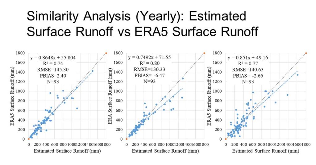
The observed discharge and ERA5 surface runoff are used to validate the estimated results in regulated basins and non-regulated basins separately. The validation result with observed data in non-regulated basins better perform R2=0.84, RMSE=34.96 and PBIAS=2.56 while R2=0.69, RMSE=35.33 and PBIAS=6.40 in regulated basins. The model underestimated the observed surface runoff. In the validation with ERA5 surface runoff for all basins, two methods are highly correlated (R2 > 0.7) and errors seems to go with surface runoff. The method generally overestimate the ERA5 (bias) and this overestimation has similar affect for different years. Finally, the mythological and hydrological parts of the model based on estimated results are discussed.